About & Community Action
The Turning Mill Neighborhood is an area of Lexington, Massachusetts featuring about 150 homes built between 1956 and 1963. The neighborhood encompasses the northwest corner of Lexington, nestled between Bedford to the west, Route 3 and Burlington's Landlocked Forest to the north, Route 95 to the east and Grove Street to the south and includes Turning Mill Road, Gould Road, Dewey Road, Partridge Road, Grimes Road, Jeffrey Terrace, and Demar Road.
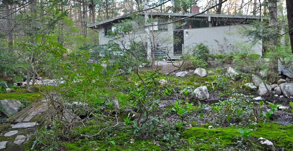
There are two primary architectural styles in the neighborhood - Techbuilt and Peacock Farm homes. The homes were all designed to maximize privacy and the residents' proximity to nature, sited on wooded lots and surrounded by community green space and recreation areas including Paint Mine conservation area and Burlington's Landlocked Forest. There is a neighborhood pool, Paint Rock Pool, where residents gather in the summer. The conservation areas provide year-round recreation, with over 15 miles of hiking/mountain biking trails, and are home to a wide array of wildlife including deer, fox, coyotes, birds and amphibians in its numerous vernal pools and wetlands.
Many of the original neighborhood residents worked at Harvard and MIT, and many were involved in the sciences through work at nearby Lincoln Laboratory. Peter Glaser (1923-2014) had the only science experiments still active on the moon. There were very significant non-scientist residents as well! David Epstein (1930-2002) was a well-loved conductor at MIT for 30 years. Jon Landau, Bruce Springsteen's manager/producer, grew up on Turning Mill Road. Renata Cathou was one of the early female pioneers of sorts, acquiring both a B.S. in 1957 and a PHD in 1963 from MIT.
Did You Know?
The History of Community Actions in theTurning Mill Neighborhood
This is how we got to this place and it is not by accident. For almost 50 years residents of this neighborhood have taken action on a number of issues to protect the character of their community. Threats to the prized and valued woodland setting of the neighborhood have motivated neighbors to work together and support others in their efforts as well. The Landlocked Forest (LLF), Hennessey Field and Paint Mine together with other local parcels of protected land, creates a contiguous 700 acres wildlife habitat and highly valued community resource.
Past and current neighbors have devoted thousands of hours to save the forests surrounding our neighborhood, the forest that filters through our neighborhood and contributes to its character. A neighborhood that local historical preservation estimates is the largest concentration of award winning architect-designed mid-century modern homes in the Northeast region.
Now the threats of overdevelopment in a quickly changing Lexington has spurred on neighbors to once again take action to protect the whole.
What follows is some detail of that story – the story continues on and now it is our turn.
The Landlocked Forest
Between 1970 and 1986 Turning Mill neighbors both spearheaded and supported the work of Bedford and Burlington residents to protect the LandLocked Forest by preventing the commercial development of a 248 acre parcel that borders the neighborhood. Engaging State Representatives, Senators, Transportation Committees, Federal Transportation Committee House Ways and Means, Water Resources Commission, Department of Public Works, Burlington Mall Trust, Metropolitan Area Planning Council - MAPC, Department of Natural Resources, Mass Department of Health, Lexington, Burlington and Bedford Boards of Selectmen, Planning Boards and Town Meetings. Many members of this community – more than can e listed - have committed many hours and years protecting the land around the neighborhood. Mr. & Mrs. Gilson of 35 Turning Mill Road even traveled to Washington DC to meet with the Federal Highway Administration. The local concerns also led to the formation of groups like the Tri-Town Civic Association and the North Lexington Association.
In 1969, the 248 acre wooded parcel that is now known as The Landlocked Forest located between Route 3 in Burlington, a neighborhood in Bedford and Lexington’s Turning Mill and Partridge Roads, was re-designated from residential to industrial. In October 1970, a petition was submitted to land court, to register rights to a cart path through the properties at 2 Grimes and 45 Turning Mill Roads that would provide access and allow for development of that parcel. Fearing that the registration of this right of way and development of the parcel as a large office park would turn their quiet neighborhood into a thruway, several neighborhood residents on Turning Mill and Partridge Roads, Margolia & Lloyd Gilson, Anne & Paul Vohl, Nancy & Albert Triesman and Diane & Paul Goldstein, objected to this attempt in a letter to land court.1 The registration request was denied.
In an effort to gain access to the parcel that was now landlocked because of the efforts of the Lexington residents, Burlington House Bill #3344 called for the construction of a bridge or a tunnel over or under Route 3 in Burlington to create access to the parcel. In April House Bill #3344 was reported on favorably by the Committee on Transportation, which prompted Dr Donald Taylor, to write a letter to then Governor Francis Sargent “strongly urging” him to veto the bill. 2
At a May 1971 Burlington Board of Selectmen meeting Attorney Rudy Haas spoke for about twenty Lexington residents present in opposition to the bill but HB#3344 was approved. The argument that the tax benefit outweighed the abutters concerns with water and traffic was a powerful lure. ‘Without the “Home Rule” Amendment, the passage of the Vigneau Bill (#3344) would be a virtual guarantee for the development of the 248 acres of land.’3
Neighbors were discouraged but not defeated. A 5 page letter authored by N.K. Demas, (formerly from 19 Partridge Rd), dated May 12, 1971 noted that with consideration of each new development there is a “disregard to the true impact on the tax-base to all the communities affected” and “to future town appropriations for essential costly services, road expansion, sewage water safety and health considerations” and “to efficient town government, planning and control, etc. as the prime vehicle of reducing costs and thereby providing needed tax relief to the community without resorting only to expansion of more industries.”4 This was ringing true for many Burlington residents who were concerned by the effects on traffic congestion, overburdened infrastructure, evidence of contamination of water supply in Bedford and the strain on public services that they had seen with the construction of the Burlington Mall in 1968 and the Northwest Industrial Office Park. Local support to prevent development of the parcel grew.
Fearing that another attempt could be made for access from the Turning Mill neighborhood, at a May 1971 meeting of the Lexington Board of Selectmen to discuss Bill #3344, Allen Lee Whitman and Donald Taylor asked to have an article inserted into the Town Warrant for the June 14th Special Town Meeting to have Lexington take by conservation, a strip of land that would block access to the parcel through Lexington.5 Board of Selectmen Chairman Robert Cataldo responded “There will be no access from Lexington. We would fight tooth and nail.”5
In June, article 10 presented by Natalie H. Riffin, town meeting members voted to pass article 10,6 and “established a protective buffer between Lexington residents and a 250 acre industrially-zoned but currently undeveloped parcel in Burlington.”
Again, a letter writing campaign ensued. 7,8, 9, 10 The Tri-Town Civic Association submitted a seven page memorandum titled FACTS CONCERNING H.3344, outlining “six compelling reasons” to kill #334411 and the Bedford Board of Selectmen “sent a special delivery letter to senator Ronald C MacKenzie (who represented Burlington, Bedford, Lexington and Carlisle) urging defeat of the bill”. 12 The Burlington House Bill #3344 did not make its way out of the Senate Ways and Means Committee.
In Feb 1972, at a Joint Committee on Transportation meeting, Burlington bill #3468 was presented. The bill H-3468 a similar bill to H-3344, would authorize access to the same 249-acre parcel. There were more than three hours of testimony. Architect Charles Hagenah of Turning Mill, made a presentation13 to show projected density and resulting congestion. Using aerial photographs of the Northwest Industrial Park in Burlington as a comparative, he laid them over the proposed development site with great affect. His use of architectural maps to demonstrate the potential flow of traffic and argument that the feeder streets could not support the volume was in opposition to the argument that the added traffic was not an issue and could be corrected for “afterwards”. 13
The Lexington Planning Board submitted a letter to the House Transportation Committee in opposition to H-3468. “We are against proceeding with underpasses when the impact of the decision is still undetermined.”14
In a separate attempt in the 1970’s, a former owner of one of the lots that the town of Lexington acquired for conservation land, threatened to sue the town for the loss of access to the Burlington LandLocked Forest. He had also bought the property at 33 Turning Mill and intended to tear down the house and put in a road to the Burlington acreage. In a panic, an article was prepared to be submitted to the Lexington Town Meeting Warrant in an effort to allow the town to offer him back the land. The measure was strongly opposed by the Precinct 7 Town Meeting Members and the North Lexington Association and never came to fruition.
Subsequently there have been numerous other attempts and for a time almost yearly submissions of bills to develop the land and more support from Turning Mill neighborhood neighbors to their Bedford and Burlington counterparts to protect the parcel. Between 1971 and 1986, there were approximately 7 bills submitted to the State, Burlington, Bedford and Lexington governing bodies, residents sent many letters to many of those same and more government bodies, senators, representatives, and heads of departments. Numerous reports were created and presentations made. One letter to John Finnegan of the Committee on Ways and Means, written by Carol Amick, State Representative remarks “This bill has been filed for three years and has been killed every year…Over the years both Bedford and Lexington have studied the impact of developing this land for it is a water storage area for hundreds of acres of the surrounding land. Both Bedford and Lexington are opposed to developing this land because of water, drainage and traffic problems.” 15
Generally, liabilities listed were; heavy industrial traffic funneling into residential areas, loss of natural settings, ecology and flooding, health-sewage problems, impact on community services such as police and fire protection, inability to sustain obligations of mutual aid agreements, increased traffic at an estimated 25,795 “trip ends”*, lack of compatibility with nearby neighborhoods, loss of privacy and urbanization, loss of habitat for wildlife, negative effects on property values, the need for increasing road capacity and costs associated, pollution and the contamination of Bedford and Burlington well water (both towns are now part of the MWRA system) to name a few.
In September 1985, the Burlington Town Meeting voted on HB4911 to acquire the Land Locked Forest parcel and the vote was upheld in a November 1985 Special Meeting.
{In May 2008, attempting to convince the Town of Burlington to sell the land, Patriot Partners, a local developer who had previously bought an option to buy the land if the Town of Burlington decided to sell it within 20 years of the eminent domain land taking, requested of Town Meeting that they establish a committee to discuss their development proposal. The May 2008 Town Meeting created the “Landlocked Parcel Committee” which involved representatives from the Board of Health, the Board of Selectmen, the Land Use Committee, the Conservation Commission, the Planning Board and several Town Meeting members. After several months of thoughtful study and discussion, the Landlocked Parcel Committee voted 6 to 3 against further discussion with Patriot Partners.
A group of Lexington residents formed The Friends of the LandLocked Forest to pursue a permanent solution to the threat of development in the LLF. Beth Zonis and Ron Levine of Gould Rd., Wendy and Mark Gabrenya of Partridge Rd., Christine Southworth and Evan Ziporyn , Alex Dohan, Carolyn Levy, MaryAnn Vetterling of Turning Mill Rd., Bob Creech, Bill Lenderking of Grimes Rd, John Frankowich of Dewey Rd., Marcia Miller of Partridge Rd. as well as many other residents of Lexington, Burlington and Bedford.
In October, 2008, Burlington Town Meeting also voted against further discussion, thereby ending the Landlocked Parcel Committee’s work.
In 2009 the Burlington Board of Selectmen gave permission for the Friends of the Landlocked Forest to mark trails clearly in order to facilitate the safe and enjoyable use of the land.
In 2010 volunteers built an information kiosk at the parking lot entrance and constructed boardwalks to protect the wetlands. The Burlington Cub Scouts created and numbered trail junction signs.} 16
In 2012 Burlington Town Meeting voted to accept an enabling bylaw to create a designation of Open Space.
At long last January 23, 2017, after numerous failed attempts, Burlington Town Meeting voted to approve an article on their town warrant to move the LLF to the designation of Open Space, a move that was supported and long hoped for by residents of the Turning Mill neighborhood.
Hennessey Field
In 1962, the Town of Lexington acquired a 10acre parcel of land from Mary A Hennessey. It lies at the ends of Mountain and Robinson Roads and abuts the Paint Mine conservation land creating a large track of undeveloped land. It is half open meadow and contributes a diversity of open space to the wooded acres around it. Through the next two decades there were efforts to develop the land until in 2000 Town Meeting voted to transfer the parcel to Conservation land.
Paint Mine
In 1976 over 19-acres that lies between Grove Street and Turning Mill Road, were designated as conservation land. The tract of land is called Paint Mine due to an ochre deposit. In the 1860’s the mineral was mined for tinting paint and the former mine is still visible along one of the conservation trails that wind their way through the partially wet lands.
Mountain Road
In the fall of 2013 a proposal was submitted to subdivide and develop a 2-acre parcel with a cul-de-sac and construct four new houses on the edge of Hennessey Field. Mountain Road is a small lane with just two houses, one being a house originally built 1753 and moved to it’s present site in 1978 to save it from demolition. A neighbor, alerted to the proposed development realized that the developer must have measured incorrectly. Dan Castognozzi contacted the town informing them that in fact the parcel lacked the required frontage to complete the proposed road. The Lillianfeld’s hired an attorney. Over 140 neighbors signed a petition against the plan. The children of the group Save Tomorrow also completed a petition and presented it to the Conservation Commission.
Finally a neighbor, Susan Hagenah refused to sell off a portion of the adjacent lot to enable the builder to fulfill the needed proportions. Faced with the solidarity of the neighborhood, the builder backed away from the deal when a reduction in the number of houses in the plan would have been required. The builder has gone on to develop Robinson Woods, Grey Oaks Circle and now Zero Grove Street in Lexington.
Turning Mill Neighborhood Conservation District
Now neighbors are working again to protect Turning Mill. In March 2016, with support and assistance from Turning Mill neighbors, Lexington Town Meeting passed an enabling bylaw that would allow individual neighborhoods to create Neighborhood Conservation Districts. In order to form an NCD, a neighborhood must establish that there are cohesive attributes, historical significance and defining characteristics that can be measured and documented –“scale, size, type of construction, materials, or style or age of its buildings and structures or its land use patterns and landscaping”.12
An NCD would allow our neighbors to determine what they felt was most important about the community in which they lived and could enact protections to preserve those characteristics and protect their properties - in this case from the threats of tree clearing and dense overdevelopment occurring in many neighborhoods throughout Lexington.
The local historical preservation estimates that Turning Mill neighborhood has the largest concentration of architect designed mid-century homes in the Northeast. The LandLocked Forest expands through our neighborhood and benefits from the woodland setting here. It is our turn now to fight to preserve these assets for Lexington and generations to come.
The Turning Mill neighborhood is working to create an NCD bylaw to bring to a Town Meeting vote in the spring of 2018 – again, it’s now our turn.
1. Rudolph Kass, Letter to Land Court , representing Paul Vohl et all, May 17, 1971 IN THE MATTER OF THE PETITION FOR REGISTRATION NO.36798 (PETITION OF PHILIP TAYLOR), represented by Jack Moss to Land Court, 13 October, 1970,
2. Donald A. Taylor M.D. letter to Francis W. Sargent, Govenor of the Commonwealth of Massachusetts, April 22, 1971
3. Burlington Times-Union, Thursday, May 20, 1971
4. N K Demas, open letter, May 12, 1971
5. Lexington Minuteman, May 6, 1971, Residents ask Board to Act on HB3344
6. Article 10 AS PASSED AT THE SPECIAL TOWN MEETING HELD JUNE 14, 1971, Mary McDonough Town Clerk
7. Lexington Minuteman, September 9, 1971 Two Bedford Boards Urge Area Residents Write to Sen. MacKenzie on HB3344
8. Mr & Mrs Vohl Letter to Hon. Sargent Governor, May 1971
9. Edward Morrow/Governor Sargent May 18,1971 response to Lloyd Gilson letter
10. Charles Kennedy Water Resource Commissiion, May 5, 1971 response to Donald Taylor letter
11. Tri-Town Civic Association - Facts Concerning H.3344, June 24, 1971
12. Lexington Minuteman, Steven Czetli , Lack of Development Plans Stall Action on Burlington Bill, Aug(?), 1971
13. Lexington Minuteman, Steven Czetli, Traffic, Water And Lex. Abutters still Issues In Burlington Access Debate, Feb 29 1972
15. letter to John Finnegan of the Committee on Ways and Means, written by Carol Amik, State Representative regarding Senate Bill 199.
16. Compiled from the Friends Of The LandLocked Forest Website
Studies and Reports
*Howard, Needles, Tammen & Bergdorf Report, 1971 commissioned by the Lexington DPW
ANALYSIS OF ROUTE 3 LANDLOCKED PARCEL:BURLINGTON by the Metropolitan Area Planning Council, April 1979
THE MASSACHUSETTS WETLANDS PROTECTION EXPERIENCE
A DRAMA IN SIX ACTS AND MANY SCENES, Allan Noam Williams, May 1973
Bannon Hill Corporate Center A Cadillac Fairview Development, 1985
Oct 29, 2017
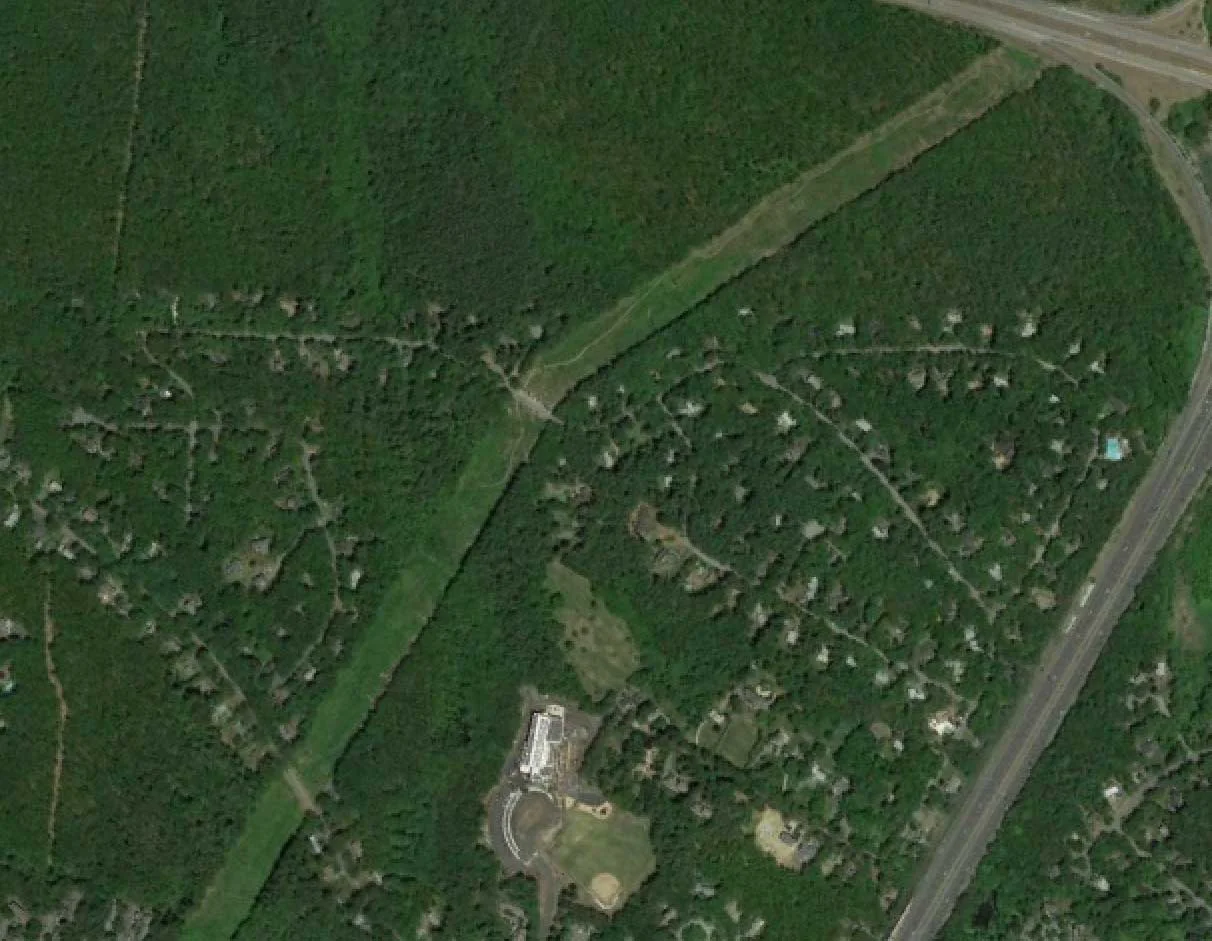
Nestled in the northwest corner of Lexington and bordered by Route 3 to the north and Route 95 to the east.